GIS-technologies to improve safety and entertaining aspect of mass orienteering events in megalopolises
Фотографии:

ˑ:
A.A. Ermachenkov1
PhD V.A. Byrkin1
1National Research Nuclear University MEPhI, Moscow, Russia
Keywords: orienteering sport, safety, GIS technologies, competitions.
Background. Today a high priority is given to safety issues of sporting events in every sport discipline, with the extreme sports on the whole and the orienteering sport (OS) in particular being particularly sensitive to these issues for the reason that the athletes compete and train very hard acting alone in unfamiliar natural terrains where they may not always be easily accessible for immediate help service in case of one or another emergency situation. For the first aid to come as soon as possible, the rescue services need to keep track of the competitor’s precise location on a real-time basis. It should also be mentioned that presently the OS system offers only occasional opportunities for the spectators and fans to watch the competitors in some places of the course including the starting and finishing sections and some control points, and that is the reason why the entertaining aspect of the competitions needs to be advanced.
Objective of the study was to consider practical applications of modern communication tools based on geo-information systems (GIS) to help solve both of the above-mentioned problems i.e. step up the safety standards and advance the entertaining aspect of the OS events.
Methods and structure of the study. The study was based on a statistical analysis of 100 competitive orienteering races with the competitors being equipped with GIS-technology-based electronic navigation devices. We have mined data on these devices available on the market and applicable for the orienteering and other extreme sport purposes and, having analysed the data, made a conclusion on the applicability of the technology for the safety standards and entertaining aspect of the OS events advancing initiatives. Based on the study data and analyses, we offered practical recommendations on the application of the GIS-technology-based electronic navigation devices using the O-GPS Center software toolkit to improve the safety standards and entertaining aspect of the OS events.
Study results and discussion. Many issues of the OS competitive process design and management have been considered in a few studies from the global viewpoint [3, 5], with the matters of the safety standards and entertaining aspect of the OS events being always prioritized in the analyses. Safety matters are always critical for almost every sport discipline. It is not unusual, regretfully, that competitive courses in the OS turn out too difficult for the competitors with the difficulties further aggravated by hard weather conditions and inadequate skills of the athletes for success on the course. However, elite athletes are also not immune from force majeure situations even in the top-ranking OS events. In a high-ranking Leningrad region OS competition of 2014, for instance, an underage athlete lost his course and was frozen to death – for the event was not equipped, among other things, with a modern tracking system to timely track the athlete's course and actual location. Such accidents cannot but alarm and mobilise the sport community in the efforts to advance the safety standards in the national OS.
One of the objectives of the study was to offer an online tracking system applicable for competitive and training purposes, i.e. the athlete’s location tracking system with the real-time progress in the race being displayed on the referee’s monitor and/or digital board for the audience. Knowing any athlete’s exact real-time location, the rescue crew may provide a timely assistance in emergency situations including losses of the course (typical for mass or underage OS events) and incapacitating injuries forcing the athlete to quit from the race. The emergency situation qualification matters were left beyond the scope of this study although in may be pertinent to mention that the situation may be correctly assessed only when the athlete’s course and actual progress is known exactly and/or the athlete may send a help signal via an individual navigator device.
Presently there are a few technical solutions (including the application software and hardware systems) on the market applicable for the online tracking purposes. There is a wide range of the relevant GIS-technology-compatible electronic systems on the market including car navigators and GPS (GLONASS, Galileo) chips presently used in a wide gamut of mobile electronic devices including telephones, tablet PCs and different trackers offered in many models and specifications. Modern GIS technologies are increasingly common and indispensable in everyday life. Only a few years ago some GIS-technology-based applications were common only in motor sports but since then they won positions in many team/ cyclic sport disciplines including football, cycle races etc.
The tracking service making it possible to watch progress of an athlete on the course somewhere in the forest a few kilometres far from the station has long been considered as something fantastic. But the modern GIS technologies allow to track an athlete’s location on a real-time basis in top-ranking competitions including World and European championships and popular commercial events. However, the OS event organisers have long aspired for something more than that - since only the Moscow-based OS community runs up to 200 OS events per year, with 100 to 1000 and more athletes competing at a time. The growing requirements to the relevant safety systems and entertaining aspects of the events imply the real-time tracking service being provided not only in the top-ranking but also regional and local events.
Costs of the existing GPS-based transmitting and tracking systems in their sport applications [4] are normally high enough for the hardware component and relatively low for the application software, and it makes them increasingly affordable for the local/ mass OS event organisers. It could also be beneficial if some inexpensive serial GPS systems were offered by the industry to track athletes’ locations on the course. It is critical that such devices should be portable and light (within 100-150 grams at most), reasonably waterproof and shockproof, fixable on the individual sport equipment or clothing, and user-friendly.
One of the possible solutions was offered by a Saint-Petersburg-based research engineering team that basically applied a mobile phone with a GPS function for the tracking purposes, with the application software developed and offered by Mikhail Senin [1]. The new system operation logic is outlined on Figure 1 hereunder.
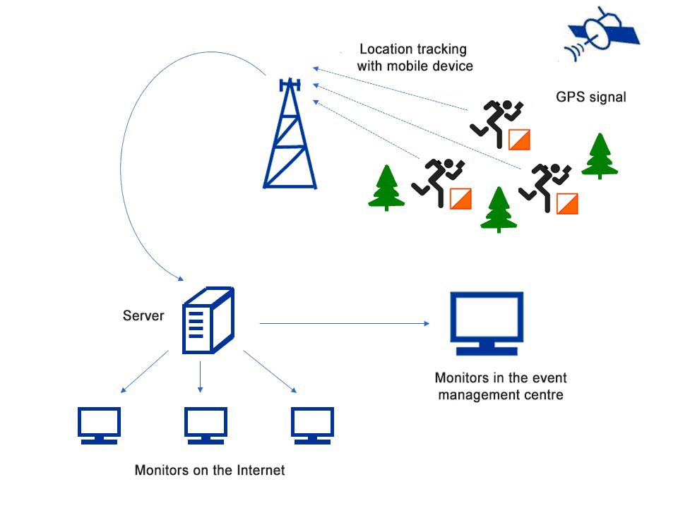
Figure 1. GPS-based tracking system operation diagram
The idea of the system is that every competitor is equipped with a mobile phone (or may use his/her own one) using an Android operational system, the phone fixable on the clothing by any fixture offered on the market for mobile phones.
At this juncture the tracking system is limited by Android operational system albeit the research team has announced [1] its progress in the Windows- and iOS-based application tools made available for the tracking devices. For the GPS-tracking capacity being operable, the mobile phone will be equipped with an active GPS module and EDGE or higher standard Internet connection, plus duly installed and customised OGPS Center Tracker client application that requires no special settings. For joining the GPS-tracking service, the client will only register the event and activate the data transmitting function.
As for the server component, the tracking capacity will be activated by the event being registered with the developers’ website and, if all the other necessary elements and data for the tracking service are available (maps with coordinates), the tracking service may be activated within thirty minutes [1, 2].
The above service activation sequence is reasonably fast and modestly priced and, therefore, applicable by any-level competitive events and even in club training processes, all the more that many competitors and coaches have their own Android-based mobile phones. One of the certain and great advantages of the proposed technology is that the competing special trackers are priced within the range of USD300 to 1000 versus the USD50 that is the price of a simple smartphone with GPS.
The only limitation of the proposed technology is that the competitive area will be covered by a high-quality mobile communication service. This means that the key condition of the technology applicability is that the events will be organised in or around megalopolises where the coverage is good enough. However, the mobile communication providers fast expand their service coverage areas and it is not improbable that the current limitation is removed in a few years. One more relative drawback of the system is the low accuracy versus the range offered by the best modern special navigation systems albeit the presently achieved location accuracy of 20-30 meters is still quite sufficient for the purposes of the service.
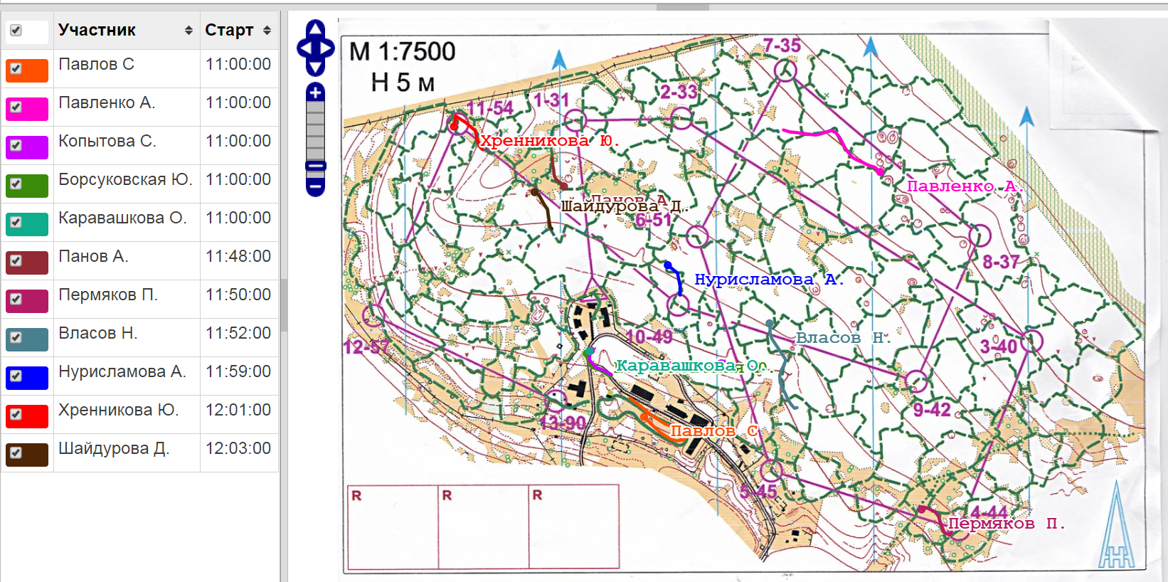
Figure 2. Screenshot of the real-time OS ski race tracking system available for the Internet application and for the refereeing purposes
The proposed tracking technology was tested in different-level OS events ranging from the Russian Championship to local open training sessions [1] and proved highly efficient, particularly for the OS events in and around megalopolises. At the moment the system has been approved for the OS application in 20 regions of the Russian Federation, and the geographical scope of its application is rapidly expanding.
Conclusion. The modern GPS-based tracking service tools and the relevant post-competitive analyses are particularly important for the sport excellence process in groups of varying skill levels. Prior to the service, the analyses of errors were only possible based on the athletes’ own reports, but now the analytical data may be mined using the objective computerised tracking technologies. In addition, the tracking records may be highly helpful for event organisers in their efforts to design and manage courses both to ensure the fair play conditions and comply with the best safety standards. For example, tracking of violations including the countermoves on ski courses, crossing prohibited areas, courses across unsafe icy areas or intensive-service motorways – may be helpful for preventing fatal errors at the race planning stage that have been regretfully common for the past few years.
References
- O-GPS Center. Available at: http://o-gps-center.ru/viewer
- Ermachenkov A.A., Beschastny L.L., Byrkin V.A., Kochnov D.A., Klukin S.A. Programmnoe obespechenie raboty sluzhb informatsii i khronometrazha massovykh sorevnovanij po sportivnomu orientirovaniyu v usloviyakh megapolisa [Software operation information services and time-study of mass orienteering competitions in a metropolis]. Moscow: NRNU MEPhI publ., 2013, 54 p.
- Ermachenkov A.A. Tekhnologiya organizatsii trenirovochnykh startov [Training events planning technology]. Moscow: Academprint publ., 2008, 70 p.
- Ermachenkov A.A. Sistema ONLINE GPS translyatsii sorevnovaniy po sportivnomu orientirovaniyu v usloviyakh megapolisa [ONLINE GPS orienteering competition broadcast system in a metropolis]. NRNU MEPhI Scientific Session 2015. NRNU MEPhI publ., Moscow, 2015, vol. 3, pp. 242-242.
- Mukhina O.N., Naletov D.V., Prokhorov A.M. Kak provesti sorevnovaniya [Competition staging procedure]. Voronezh: VSU publ., 2008, 159 p.
Corresponding author: aaermachenkov@gmail.com
Abstract
The growing popularity of mass orienteering events has brought to the forefront a few critical challenges. First, a top priority needs to be given to the safety of competitors since the orienteering events with their forest/ rough terrain racing activities are always associated – even in good weather conditions – with high risks of injuries (from sharp boughs, falls on cliffs, in ravines etc.). And, second, the entertaining aspect of the events needs to be advanced. The present study considers promises of modern communication tools based on the geo-information systems (GIS) application technologies to help solve the both above-mentioned problems i.e. advance the safety standards and entertaining aspects of the events. The study data give the means to offer new technological solutions to make it possible to step up, on a cost-efficient basis, the safety and management standards and the entertaining aspect of the orienteering sport competitions.


 Журнал "THEORY AND PRACTICE